Ground Penetrating Radar Services
Geoscanning
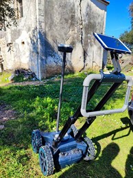
Geoscanning refers to the process of using advanced technology to gather data of the subsurface geology and terrain of an area. This is typically done by using geophysical instruments, such as ground-penetrating radar, electromagnetic induction, and seismic surveys.
Geoscanning is widely used in various industries, such as mining, oil and gas exploration, civil engineering, and environmental science, to help identify and map geological structures, locate mineral deposits, assess potential hazards and risks, and plan and design construction projects.
By using geoscanning, engineers and geologists can get a detailed understanding of the subsurface conditions, which can help them make informed decisions and reduce the likelihood of costly mistakes and accidents.
Geoscanning can be used in a variety of applications such us, Damage prevention / Excavation safety / Utility locating & mapping / Subsurface utility engineering (SUE) / Surveying & Reality Capture / Road inspection / Bridge inspection / Geophysical investigations / Archaeology / Forensics & UXO / Precision Agriculture